Burlington Route freight trains, 1947

Burlington freight, 1947 map thumbnail

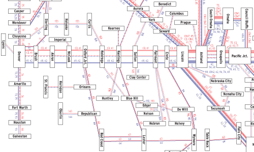
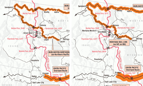
If you want a glimpse of railroad operations six decades ago, this map of the Chicago, Burlington & Quincy provides a window. It’s based on Burlington’s November 1947 freight train operating plan, a chart of schedules furnished to company officers. (Our map was modified to put eastbounds and westbounds on one page and converted to […]

Read More…

Natural resources in Kansas City Southern’s territory

Kansas City Southern natural resources map image

This map of the Kansas City Southern and Louisiana & Arkansas (just prior to their 1939 operational merger) is based on a document undoubtedly produced by the KCS traffic department to show shippers the abundance of natural resources within the roads’ territory. KCS founder Arthur Stilwell had left his secure position with a Hartford insurance […]

Read More…

Evolution of Canada’s grain network

Evolution of canada’s grain network image

Three distinct periods of railway construction created the grain-gathering network that served the farmers of Manitoba, Saskatchewan, and Alberta. The first 3,000 miles were built between 1881 and the onset of a depression in 1893. Better times returned in 1896, fueling an incredible boom that saw the construction of more than 11,000 route- miles by […]

Read More…

Railroad tonnage by state in 2004

Railroad tonnage by state in 2004 map image

If you want to sense the impact of coal on the railroad industry, consider this: The state that ranks last in population — Wyoming, with a little more than 500,000 residents — originates one of every five tons of freight hauled by American railroads. The 419 million gross tons that began its journey in Wyoming […]

Read More…

Western power plants

Western power plants map thumbnail

Coal is the No. 1 rail-shipped commodity by tonnage in the U.S., and power plants consume most of it. Three key characteristics shape this map (see June 2002 Trains for the East, and January 2003 for the South): Population is concentrated in cities; most plants are mine-mouth or near the mine; and its most populous […]

Read More…

The great American roundhouse

Connellsville, Pa., roundhouse

American roundhouse Roundhouses were found all across the nation once. Now they’re rare gems. These structures began disappearing after the dieselization era. Only a few were left in use by some railroads. Many were eventually demolished or repurposed. Here’s a gallery of them under construction, in use, and after the wrecking ball. […]

Read More…

Mainline tonnage, 1980/2005

Union Pacific predecessors map thumbnail

Jeff Wilson and Robert Wegner This Map of the Month appeared in the February 2007 issue of Trains magazine. Twenty-five years separate these two maps showing the busiest freight railroad lines in the United States. The 1980 map depicts American railroads at the end of regulation — the Staggers Rail Act of 1980 was signed […]

Read More…

BNSF 4617 East at summit of East Ash Hill

Though half of its train continues to ascend a 1.0 percent grade, BNSF 4617 East has crested the summit at East Ash Hill, about seven miles east of Ludlow, Calif., on the morning of Oct. 8, 2009. Within a few thousand feet, all 50 autoracks of BNSF Train V-SDGCLO1-07 (Vehicles, San Diego, Calif. — Clovis, […]

Read More…